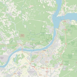
The main water resources of Perm are represented by two large rivers – the Kama and the Chusovaya. The Kama River extends to 1805 kilometres. 73,718 tributaries flow into the Kama. Most of them are small rivers up to 10 km long.
For centuries, the Kama and the Chusovaya rivers have served not only as a water resource. In those days, when there was no air or railway communication, these rivers were the main ‘roads’ of Perm. And nowadays navigation is widespread on the Kama. In summer time, passenger ships operate on routes connecting the Russian cities of Perm, Moscow, Nizhny Novgorod, Astrakhan and Ufa. The port of Perm is located on the left bank of the Kama. The port has its own cargo fleet (pusher tugs and barges), which provide cargo transportation.
The Kama and the Chusovaya are places of recreation and fishing. Of all the types of recreation on the rivers of Perm, rafting is especially popular. Starting from the first days of May until late autumn, a huge number of tourists go rafting using kayaks, catamarans and rafts.
The Kama and its tributaries are attractive sites for fishing enthusiasts. Sterlet, bream, sturgeon, wild carp, crucian carp, ide, zander, perch, ruff, pike, etc. live in the river and its tributaries. In the upper reaches of the river and in the waters of the tributaries, you can catch taimen and grayling.
In winter, the Kama freezes over. Ice forms in November. Ice drift begins in April and can last up to 2 weeks. During the season, the water level in the river can fluctuate by up to 8 metres. In terms of its annual water flow, the Kama as a tributary is the third largest in Russia.
The Chusovaya is a left tributary of the Kama River. The total length of the river is 592 kilometres. Numerous rivers and streams flow into the Chusovaya (about 150 tributaries in total). The river freezes in late October to early December. The spring ice drift begins in April to early May. In the lower reaches of the river, ice floes often accumulate, as a result of which the water level can rise by up to 2.8 metres.
The city of Perm is located between two reservoirs. The main part of the city as far as the Kama dam is situated on the Votkinskiy reservoir and part of the Ordzhonikidzevskiy district above the dam is on the Kamskiy reservoir. These reservoirs were formed by the Kama and Votkinsk hydroelectric plants, which were put into operation in 1954 and 1961 respectively.
Perm is unique because within the city limits there is a large number of small rivers. In the 1980s, there were more than 300 small rivers and streams in Perm. Most of the city centre is located in a raised area between two small rivers, the Yegoshikha and the Danilikha. It is particularly with the river Yegoshikha that the history of the formation of the city of Perm is bound. Here, in 1723, the Yegoshikha copper-smelting plant and the factory settlement of Yegoshikha with its fortress were founded, giving rise to the city that subsequently became a provincial centre. It is from this moment that the history of the city began. In 2023, the city of Perm will celebrate its 300th anniversary.
The length of the city’s lesser rivers (the Yegoshikha, the Danilikha, the Iva, the Motovilikha, the Balmoshnaya, the Yazovaya) does not exceed 10 km and the width, on average, is 2-3 metres. Their tributaries, the Styx, the Chumka, the Malaya Motovilikha and others are even smaller.
Rivers of greater length also flow through the city, for example, the Mulyanka and the Gaiva (several dozen kilometres), but in Perm they are present only in the lower reaches and in the estuarine part.
There are more than 120 springs in Perm, which are of great importance in feeding other surface water bodies and maintaining water balance.
The construction of a city water supply system in Perm has a long history: back in September 1879, the Perm City Council decided to commemorate the 100th anniversary of Perm with a water supply system. However, the centralised water supply in the city began to develop only in 1907, when the first stage of the city water supply was put into operation. The Bolshoi Kama water pipeline was built in 1930-1931. In 1938, the water treatment facilities of Bolshekamsky water intake were put into operation. Later, the water treatment facilities of the Bolshekamsky water intake were expanded in 1954, 1957 and 1964. The year 1970 was marked by the completion of the construction of the Chusovoy water treatment facilities (CHOS).
In simple terms, the modern urban centralised water supply system finally took shape by the 1970s - 1980s.
The history of the Perm embankment begins at the end of the 19th century, when a walking path was made on a small area along the Kama River, beyond the Perm-1 railway station. It was possible to walk on it in good weather. However, the creation of a proper place for walks along the bank of the Kama River began only in the 1960s, when, together with the construction of a communal bridge, a section of the Kama river bank was improved and handsomely upgraded.
Thanks to the Kama, Perm is connected by waterways with five European seas: the Caspian, the White, the Black, the Azov and the Baltic seas. The river is the heart of our city and the most important transport artery of the country.
The Kama is a great Russian river. Anyone who has ever once admired the beauty of the Kama will forever keep its image in their heart. It will always be a symbol of Perm, a symbol of Russia. The amazing beauty of the Kama will remain a source of inspiration for poets, writers and artists.
Maria Reymers
Perm, Rivers Kama & Chusovaya

Sections